What is the Uralla Groundwater Investigations Project about?
Water security is essential to the future of Uralla Shire. The Uralla Groundwater Investigations Project is exploring whether groundwater can provide an additional water source to help support the community during droughts and other emergency situations.
Between 2018 and 2020, Uralla Shire and surrounding areas experienced a severe drought. During this period, water levels in Kentucky Creek Dam, the township's primary water supply, fell below 25% capacity, resulting in significant water restrictions.
These conditions highlighted the importance of investigating additional water supply options to improve the Shire's long-term water security and resilience.
Put simply, future droughts are inevitable. By identifying potential supplementary water sources now, Council can better prepare for future challenges and help ensure a more reliable water supply for the community.
Photograph: Kentucky Creek Dam during the 2019-2020 drought, showing critically low water levels and exposed sediment.
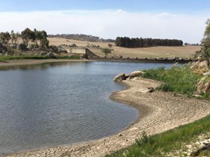 Photo of Kentucky Creek Dam in drought 2019
Kentucky Creek Dam Capacity Assessment
In May 2024, Council commissioned a survey of Kentucky Creek Dam to better understand its current storage capacity.
The survey measured the depth of the dam and compared its current condition with its original design. This work helped estimate how much storage capacity has been lost over time due to the build-up of sediment.
The assessment found that Kentucky Creek Dam has lost approximately 30% of its original storage capacity as a result of sediment accumulation.
This information provides valuable insight into the dam's current capacity and will help inform future water security planning for Uralla Shire.
Strategic Water Planning Study Funding
In 2024, Uralla Shire Council received funding of up to $855,315 through the NSW Government's Safe and Secure Water Program to support the development of a long-term water strategy for the community.
The funding is helping Council better understand future water security challenges, assess potential solutions, and develop a 30-year plan for water and wastewater services across the Shire.
As part of this work, a range of studies and investigations are being undertaken to identify potential risks to water supply and wastewater services, and to explore options for improving reliability, resilience and sustainability.
To learn more about the Strategic Water Planning Study, visit the Water Security Study page or Council's website: Water Security Study Have your Say page and Uralla Shire Council's Website
Why Investigate Groundwater?
The NSW Government provided Uralla Shire Council with $1.5 million to investigate potential alternative water supply sources that could help strengthen water security for the community.
The initial focus of this work is to determine whether a suitable groundwater source exists near Uralla that could supplement supplies from Kentucky Creek Dam during droughts and other emergency situations.
Having access to additional water sources is an important part of preparing for future droughts. Groundwater is widely used across Australia for irrigation, livestock, and town water supplies, and can provide a reliable source of water when surface water supplies are under pressure.
If a suitable groundwater source can be identified close to Uralla, it could help improve the resilience of the town's water supply while reducing the need for costly pipelines and pumping infrastructure from more distant locations.
The NSW Government provided Uralla Shire Council with a grant of $1.5M
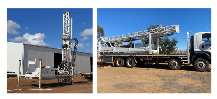 Impax Drilling Equipment
What does the Uralla Groundwater Project involve?
The Groundwater Investigations Project is assessing whether groundwater can provide a reliable supplementary water source for Uralla during droughts and other emergency situations.
For groundwater to be a viable option for town water supply, it must:
- Be available in sufficient quantities to meet community needs.
- Produce enough water to support ongoing supply requirements.
- Be of a quality that can be treated to meet drinking water standards.
- Be located close enough to Uralla to allow water to be transferred efficiently and cost-effectively.
Finding suitable groundwater sources in the granite geology of the Uralla region can be challenging. For this reason, the project has been undertaken in stages, with each phase designed to gather information and reduce uncertainty before progressing to the next step.
The following stages outline how Council has investigated groundwater potential and what has been learned throughout the project.
Phase 1: Review of Existing Groundwater Information (Completed)
The first phase of the project involved reviewing existing information about groundwater and geology in the Uralla area to identify locations with the greatest potential to support future groundwater investigations.
Council engaged specialist hydrogeological consultants, Harwood Environmental Consultants (HEC), to assess available geological mapping, groundwater records, existing bore information and historical mining data.
The assessment identified several locations near Uralla that showed the greatest potential for finding viable groundwater resources and helped guide the next stages of investigation.
HEC's Desktop Review Summary Report and Full Technical Report are available in the Harwood Environmental Consultant Reports section of this page.
The findings from Phase 1 helped determine where more detailed investigations should be undertaken in the next stage of the project.
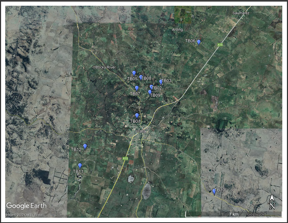 Uralla Groundwater investigations initial bore locations (HEC report)
Phase 2: Test Bore drilling (completed)
The second phase of the project involved drilling test bores to gain a better understanding of local geology and groundwater conditions.
Existing geological information for the area was limited, so test drilling was undertaken to determine whether groundwater resources near Uralla could provide a viable supplementary water supply. The investigations helped assess groundwater availability, potential water yields, water quality, and the possible long-term impacts of groundwater extraction on the environment and nearby bores.
Based on earlier investigations, Council's hydrogeological consultant recommended drilling 12 test bores, primarily north of Uralla.
These locations were selected because geological mapping indicated the presence of ancient basalt overlying granite formations. The boundary between these rock types was considered one of the most promising areas for finding groundwater.
The drilling program also helped identify whether multiple groundwater-bearing layers (aquifers) existed at different depths below the surface.
The findings from the test drilling program helped identify the most promising groundwater sources for further investigation and testing.
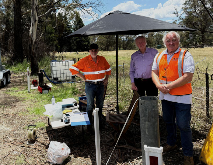
Harwood Environmental Consultants (HEC) conducted the test bores drilling under the supervision of Uralla Shire Council’s Project Manager Rod Williams
Phase 3: Groundwater Access Approvals (Completed)
Following several years of investigations and testing, Council progressed to the next stage of the project by seeking approvals to use groundwater as a supplementary water source for Uralla when needed.
Based on advice from Harwood Environmental Consultants (HEC) and Mark Campbell Water Advisory, Council applied to the NSW Department of Climate Change, Energy, the Environment and Water (DCCEEW) for two emergency Specific Purpose Access Licences (SPALs) for bores TB06 and TB07.
If approved, these licences would allow Council to access groundwater during periods of high demand or reduced water availability, such as droughts or other emergency situations. Groundwater would supplement supplies from Kentucky Creek Dam and help strengthen the resilience of Uralla's water supply system.
The proposed extraction limits are:
- TB06: 35 Megalitres per year
- TB07: 105 Megalitres per year
These proposed limits are subject to assessment and approval by DCCEEW and are based on investigations undertaken to understand the long-term sustainability of groundwater extraction.
Throughout the project, Council worked closely with NSW Government agencies to minimise potential impacts on existing groundwater users. The selected bore locations are situated on road reserves, Crown land, or other Council-controlled land and are located well away from existing stock and domestic bores.
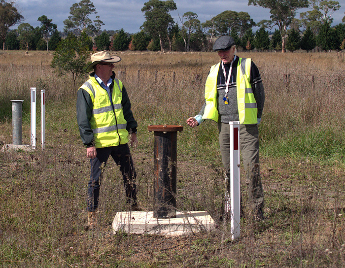 Bore TBO6
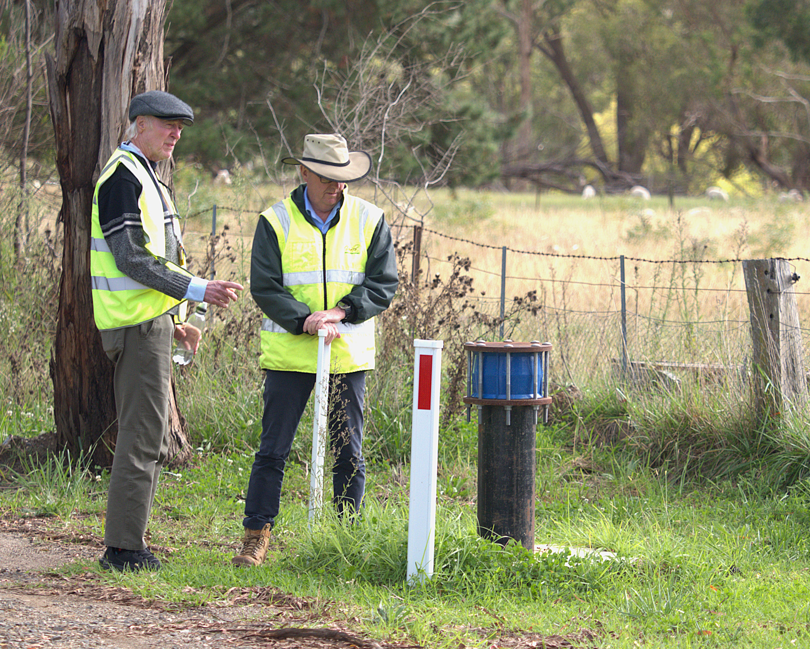 Bore TB07
Photograph of Uralla Shire Council Director of Infrastructure Mick Raby and Manager of Groundwater Project Rod Williams inspecting TBO6 and TB07 (May 2025)
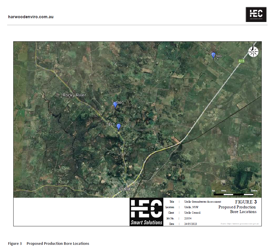
Map Locations of Uralla Groundwater final 2 Production Bores TB06 & TB07 (TB05 not progressed to a production bore)
Phase 4: Specific Purpose Access Licences Approved (Completed)
Application for a new specific purpose water access licence (SPAL) This is an application for minister’s approval for a new specific purpose access licence (SPAL) under section 61 (1) (a) of the Water Management Act 2000. A SPAL specifies the purpose it can be used for and may limit the operation of the SPAL to a particular location where it can be used. A SPAL will be cancelled if the purpose for which it was granted no longer exists.
Specific Purpose Access License (SPAL) for Council's two groundwater bores TB06 and TB07 have been approved by the NSW Department of Climate Change, Energy, the Environment and Water, Licensing & Approvals | Water Group. (NSW DCCEEW)
TB06 bore extraction limit - 35 Megaliters
TB07 bore extraction limit - 105 Megaliters.
The water extraction limits are the result of NSW DCCEEW assessment using the a/go water modelling tool which assesses the long-term impacts of the bores.
More information can be found on the NSW Government Water Allocations - managing extraction limits
Phase 5: Specific Purpose Water Access Licence Registration (Completed)
Following approval of the Specific Purpose Access Licences (SPALs), the final step is the formal registration of the water access licences.
Council completed the required registration documentation, which was submitted to NSW Land Registry Services for processing and registration for the granting of Certificates of Title.
The registration of these licences completes an important milestone in the Groundwater Investigations Project and supports Council's ability to access groundwater as a supplementary water source during future droughts or emergency situations.
Further information about water access licence registration is available from NSW Land Registry Services. https://www.nswlrs.com.au/services/water-access-licence/
Phase 6: Certificates of Title - WaterNSW - 71W Dealings. (In progress)
Following the granting of Certificates of Title for Uralla Groundwater bores TB06 and TB07.
The water access licences (WALS) have now been formally registered and sent to WaterNSW to be linked to the approved WaterNSW nominated works (71W Dealings). This means the licensing process is nearing completion and when complete the bores will be available to Council for use in accordance with their licence conditions.
The licences support the use of groundwater as a supplementary water source for Uralla during periods of high demand, drought, or other emergency situations
Approved Water Access Details
Licence Category: Local Water Utility – Domestic and Commercial
Water Source: New England Fold Belt Murray-Darling Basin Groundwater Source
Water Sharing Plan: NSW Murray-Darling Basin Fractured Rock Groundwater Sources 2020
Approved Extraction Limits
- TB06: 35 Megalitres per year
- TB07: 105 Megalitres per year
Further information about water access licensing is available from WaterNSW and the NSW Department of Climate Change, Energy, the Environment and Water. https://www.waternsw.com.au/customer-services/water-licensing
Phase 7: Future Development and Implementation (Proposed)
When the groundwater investigations and licensing process is completed, the project will move into the next stage of planning and development.
Council is continuing discussions with the NSW Department of Climate Change, Energy, the Environment and Water (DCCEEW) regarding the role of groundwater as an emergency supplementary water supply for Uralla during droughts and other periods of reduced water availability.
The next stage of the project is expected to include:
- Detailed design and planning for the groundwater supply infrastructure.
- Assessment of construction requirements and project delivery options.
- Development of the infrastructure needed to connect the approved groundwater bores to the town water supply system.
- Ongoing consultation with relevant government agencies and stakeholders.
Once completed, bores TB06 and TB07 will provide Council with an additional water source that can be used in accordance with their licence conditions when supplementary supplies are required.
Project timing and future development milestones will be confirmed as planning progresses.
Project Funding Acknowledgement
The NSW Government provided Uralla Shire Council with $1.5 million to investigate potential alternative water supply sources for Uralla.
The initial focus of this funding was to determine whether groundwater could provide a viable supplementary water source for the township. Groundwater investigations were undertaken to assess whether local groundwater resources could help support the Kentucky Creek Dam water supply during droughts and other emergency situations.
This work forms part of Council's ongoing commitment to improving long-term water security and ensuring a reliable water supply for the Uralla community.
What is Groundwater?
This video provides an overview about Groundwater.
What is the Uralla Groundwater Investigations Project about?
Water security is essential to the future of Uralla Shire. The Uralla Groundwater Investigations Project is exploring whether groundwater can provide an additional water source to help support the community during droughts and other emergency situations.
Between 2018 and 2020, Uralla Shire and surrounding areas experienced a severe drought. During this period, water levels in Kentucky Creek Dam, the township's primary water supply, fell below 25% capacity, resulting in significant water restrictions.
These conditions highlighted the importance of investigating additional water supply options to improve the Shire's long-term water security and resilience.
Put simply, future droughts are inevitable. By identifying potential supplementary water sources now, Council can better prepare for future challenges and help ensure a more reliable water supply for the community.
Photograph: Kentucky Creek Dam during the 2019-2020 drought, showing critically low water levels and exposed sediment.
Photo of Kentucky Creek Dam in drought 2019
Kentucky Creek Dam Capacity Assessment
In May 2024, Council commissioned a survey of Kentucky Creek Dam to better understand its current storage capacity.
The survey measured the depth of the dam and compared its current condition with its original design. This work helped estimate how much storage capacity has been lost over time due to the build-up of sediment.
The assessment found that Kentucky Creek Dam has lost approximately 30% of its original storage capacity as a result of sediment accumulation.
This information provides valuable insight into the dam's current capacity and will help inform future water security planning for Uralla Shire.
Strategic Water Planning Study Funding
In 2024, Uralla Shire Council received funding of up to $855,315 through the NSW Government's Safe and Secure Water Program to support the development of a long-term water strategy for the community.
The funding is helping Council better understand future water security challenges, assess potential solutions, and develop a 30-year plan for water and wastewater services across the Shire.
As part of this work, a range of studies and investigations are being undertaken to identify potential risks to water supply and wastewater services, and to explore options for improving reliability, resilience and sustainability.
To learn more about the Strategic Water Planning Study, visit the Water Security Study page or Council's website: Water Security Study Have your Say page and Uralla Shire Council's Website
Why Investigate Groundwater?
The NSW Government provided Uralla Shire Council with $1.5 million to investigate potential alternative water supply sources that could help strengthen water security for the community.
The initial focus of this work is to determine whether a suitable groundwater source exists near Uralla that could supplement supplies from Kentucky Creek Dam during droughts and other emergency situations.
Having access to additional water sources is an important part of preparing for future droughts. Groundwater is widely used across Australia for irrigation, livestock, and town water supplies, and can provide a reliable source of water when surface water supplies are under pressure.
If a suitable groundwater source can be identified close to Uralla, it could help improve the resilience of the town's water supply while reducing the need for costly pipelines and pumping infrastructure from more distant locations.
The NSW Government provided Uralla Shire Council with a grant of $1.5M
Impax Drilling Equipment
What does the Uralla Groundwater Project involve?
The Groundwater Investigations Project is assessing whether groundwater can provide a reliable supplementary water source for Uralla during droughts and other emergency situations.
For groundwater to be a viable option for town water supply, it must:
- Be available in sufficient quantities to meet community needs.
- Produce enough water to support ongoing supply requirements.
- Be of a quality that can be treated to meet drinking water standards.
- Be located close enough to Uralla to allow water to be transferred efficiently and cost-effectively.
Finding suitable groundwater sources in the granite geology of the Uralla region can be challenging. For this reason, the project has been undertaken in stages, with each phase designed to gather information and reduce uncertainty before progressing to the next step.
The following stages outline how Council has investigated groundwater potential and what has been learned throughout the project.
Phase 1: Review of Existing Groundwater Information (Completed)
The first phase of the project involved reviewing existing information about groundwater and geology in the Uralla area to identify locations with the greatest potential to support future groundwater investigations.
Council engaged specialist hydrogeological consultants, Harwood Environmental Consultants (HEC), to assess available geological mapping, groundwater records, existing bore information and historical mining data.
The assessment identified several locations near Uralla that showed the greatest potential for finding viable groundwater resources and helped guide the next stages of investigation.
HEC's Desktop Review Summary Report and Full Technical Report are available in the Harwood Environmental Consultant Reports section of this page.
The findings from Phase 1 helped determine where more detailed investigations should be undertaken in the next stage of the project.
Uralla Groundwater investigations initial bore locations (HEC report)
Phase 2: Test Bore drilling (completed)
The second phase of the project involved drilling test bores to gain a better understanding of local geology and groundwater conditions.
Existing geological information for the area was limited, so test drilling was undertaken to determine whether groundwater resources near Uralla could provide a viable supplementary water supply. The investigations helped assess groundwater availability, potential water yields, water quality, and the possible long-term impacts of groundwater extraction on the environment and nearby bores.
Based on earlier investigations, Council's hydrogeological consultant recommended drilling 12 test bores, primarily north of Uralla.
These locations were selected because geological mapping indicated the presence of ancient basalt overlying granite formations. The boundary between these rock types was considered one of the most promising areas for finding groundwater.
The drilling program also helped identify whether multiple groundwater-bearing layers (aquifers) existed at different depths below the surface.
The findings from the test drilling program helped identify the most promising groundwater sources for further investigation and testing.
Harwood Environmental Consultants (HEC) conducted the test bores drilling under the supervision of Uralla Shire Council’s Project Manager Rod Williams
Phase 3: Groundwater Access Approvals (Completed)
Following several years of investigations and testing, Council progressed to the next stage of the project by seeking approvals to use groundwater as a supplementary water source for Uralla when needed.
Based on advice from Harwood Environmental Consultants (HEC) and Mark Campbell Water Advisory, Council applied to the NSW Department of Climate Change, Energy, the Environment and Water (DCCEEW) for two emergency Specific Purpose Access Licences (SPALs) for bores TB06 and TB07.
If approved, these licences would allow Council to access groundwater during periods of high demand or reduced water availability, such as droughts or other emergency situations. Groundwater would supplement supplies from Kentucky Creek Dam and help strengthen the resilience of Uralla's water supply system.
The proposed extraction limits are:
- TB06: 35 Megalitres per year
- TB07: 105 Megalitres per year
These proposed limits are subject to assessment and approval by DCCEEW and are based on investigations undertaken to understand the long-term sustainability of groundwater extraction.
Throughout the project, Council worked closely with NSW Government agencies to minimise potential impacts on existing groundwater users. The selected bore locations are situated on road reserves, Crown land, or other Council-controlled land and are located well away from existing stock and domestic bores.
Bore TBO6
Bore TB07
Photograph of Uralla Shire Council Director of Infrastructure Mick Raby and Manager of Groundwater Project Rod Williams inspecting TBO6 and TB07 (May 2025)
Map Locations of Uralla Groundwater final 2 Production Bores TB06 & TB07 (TB05 not progressed to a production bore)
Phase 4: Specific Purpose Access Licences Approved (Completed)
Application for a new specific purpose water access licence (SPAL) This is an application for minister’s approval for a new specific purpose access licence (SPAL) under section 61 (1) (a) of the Water Management Act 2000. A SPAL specifies the purpose it can be used for and may limit the operation of the SPAL to a particular location where it can be used. A SPAL will be cancelled if the purpose for which it was granted no longer exists.
Specific Purpose Access License (SPAL) for Council's two groundwater bores TB06 and TB07 have been approved by the NSW Department of Climate Change, Energy, the Environment and Water, Licensing & Approvals | Water Group. (NSW DCCEEW)
TB06 bore extraction limit - 35 Megaliters
TB07 bore extraction limit - 105 Megaliters.
The water extraction limits are the result of NSW DCCEEW assessment using the a/go water modelling tool which assesses the long-term impacts of the bores.
More information can be found on the NSW Government Water Allocations - managing extraction limits
Phase 5: Specific Purpose Water Access Licence Registration (Completed)
Following approval of the Specific Purpose Access Licences (SPALs), the final step is the formal registration of the water access licences.
Council completed the required registration documentation, which was submitted to NSW Land Registry Services for processing and registration for the granting of Certificates of Title.
The registration of these licences completes an important milestone in the Groundwater Investigations Project and supports Council's ability to access groundwater as a supplementary water source during future droughts or emergency situations.
Further information about water access licence registration is available from NSW Land Registry Services. https://www.nswlrs.com.au/services/water-access-licence/
Phase 6: Certificates of Title - WaterNSW - 71W Dealings. (In progress)
Following the granting of Certificates of Title for Uralla Groundwater bores TB06 and TB07.
The water access licences (WALS) have now been formally registered and sent to WaterNSW to be linked to the approved WaterNSW nominated works (71W Dealings). This means the licensing process is nearing completion and when complete the bores will be available to Council for use in accordance with their licence conditions.
The licences support the use of groundwater as a supplementary water source for Uralla during periods of high demand, drought, or other emergency situations
Approved Water Access Details
Licence Category: Local Water Utility – Domestic and Commercial
Water Source: New England Fold Belt Murray-Darling Basin Groundwater Source
Water Sharing Plan: NSW Murray-Darling Basin Fractured Rock Groundwater Sources 2020
Approved Extraction Limits
- TB06: 35 Megalitres per year
- TB07: 105 Megalitres per year
Further information about water access licensing is available from WaterNSW and the NSW Department of Climate Change, Energy, the Environment and Water. https://www.waternsw.com.au/customer-services/water-licensing
Phase 7: Future Development and Implementation (Proposed)
When the groundwater investigations and licensing process is completed, the project will move into the next stage of planning and development.
Council is continuing discussions with the NSW Department of Climate Change, Energy, the Environment and Water (DCCEEW) regarding the role of groundwater as an emergency supplementary water supply for Uralla during droughts and other periods of reduced water availability.
The next stage of the project is expected to include:
- Detailed design and planning for the groundwater supply infrastructure.
- Assessment of construction requirements and project delivery options.
- Development of the infrastructure needed to connect the approved groundwater bores to the town water supply system.
- Ongoing consultation with relevant government agencies and stakeholders.
Once completed, bores TB06 and TB07 will provide Council with an additional water source that can be used in accordance with their licence conditions when supplementary supplies are required.
Project timing and future development milestones will be confirmed as planning progresses.
Project Funding Acknowledgement
The NSW Government provided Uralla Shire Council with $1.5 million to investigate potential alternative water supply sources for Uralla.
The initial focus of this funding was to determine whether groundwater could provide a viable supplementary water source for the township. Groundwater investigations were undertaken to assess whether local groundwater resources could help support the Kentucky Creek Dam water supply during droughts and other emergency situations.
This work forms part of Council's ongoing commitment to improving long-term water security and ensuring a reliable water supply for the Uralla community.
What is Groundwater?
This video provides an overview about Groundwater.


Thank you for your contribution!
Help us reach out to more people in the community
Share this with family and friends