
FAQs based on recent consultation
Can stages 2 and 3 of Satinvale Estate go ahead under the proposed minimum lot size change for Invergowrie?
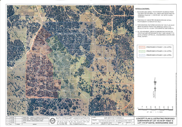
Satinvale Estate is a 56-lot subdivision first approved in February 2007. That approval remains valid and has been acted on, so a change to the minimum lot size will not affect it; the remaining lots can still be created under the existing approval.
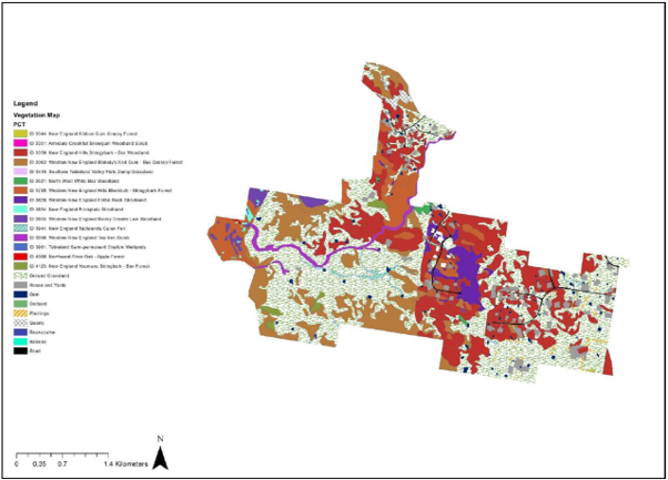
Creating a lot, however, is not the same as being able to build a house on it. Any new home will need its own development application, assessed under today's planning rules. It would need to protect koala habitat, feed trees and other native vegetation — by avoiding or offsetting impacts — and meet current bushfire requirements, including an Asset Protection Zone cleared and maintained around the house.
On heavily vegetated lots these requirements can make building difficult and costly, and in some cases, it may not be possible to build on a lot at all (despite the existing subdivision approval).
How will the change in minimum lot size affect my property in Invergowrie?
It depends on the size of your block and whether it currently has subdivision potential.
If your block is under 4 hectares, there's no change. You can't subdivide it under the current rules; a block needs to be at least 4 hectares to create two lots under the existing 2-hectare minimum.
If your block is 4 hectares or more but under 50 hectares, you can subdivide under the current rules, but under a 25-hectare minimum you generally won't be able to, because a block needs to be at least 50 hectares to create two new lots of 25 hectares each. If your block is 50 hectares or larger, you may still be able to subdivide, but any new lots must be 25 hectares or greater, meaning fewer and larger lots than the current rules allow.
The change only affects the creation of new lots. It doesn't affect existing lots or existing homes, and limited exceptions can apply, so for advice on your specific property please contact Council.
My property is within an identified core growth area. Does this mean Council is going to develop it?
No. being in a growth area doesn't oblige you to do anything with your property. Council's role is to set the planning rules and expectations for what landholders and developers can do, not to develop the land itself, and Council won't be building housing.
For land in a growth area to become new housing, the landholder must want to act on it: to subdivide, sell, or otherwise enable it to be developed. That's a choice for the landholder, not something Council initiates.
The draft Growth Management Strategy sets out the Growth Outcomes for each area. In most cases it calls for development to be guided by a masterplan for the core growth area covering road access, infrastructure servicing and lot layout, with a mix of lot sizes. This next layer of planning will help these areas develop in a coordinated way rather than lot by lot.
Will worker camps be built on the sites identified for temporary workforce accommodation and who decides where camps go?
Identifying a site doesn't mean a camp will be built there. Council can't build these and isn't proposing to, but we are trying to influence the outcome. Whether accommodation is built, and where, is up to renewable energy developers and landholders. Council has identified sites it considers suitable: on the edges of town, in areas earmarked for future growth, with few constraints like bushfire or flooding. These are site with strategic merit, where Council would be supportive, but not where camps will necessarily go.
Most of the renewable projects proposed for the Shire are on large rural properties out of town, so a developer may choose to house workers on-site, near where construction is concentrated. That keeps the day-to-day pressures of a temporary workforce away from town, which many people prefer. But locating accommodation closer to town has upsides too: workers are more likely to use local businesses and services, and accommodation placed where Council wants future residential or industrial land can leave a lasting infrastructure legacy for the town. That trade-off is the thinking behind Council's identified sites.
Who decides depends on how the accommodation is proposed:
As part of a renewable energy project. Renewable projects are assessed by the State as State Significant Development or Infrastructure. A developer can include workforce accommodation in that application, and the State (not Council) decides it. Council is consulted and its position is taken into account, but the decision rests with the State.
As a standalone proposal. Separately, Part 13 of the Housing SEPP creates a pathway for workers’ accommodation to be approved by Council through a development application. It's permitted in all residential zones, and in other zones, including rural and industrial, where Council is satisfied it's appropriate. Here, Council is the decision-maker.
In short: where a camp is proposed on-site through the State pathway, Council has limited control; through the Housing SEPP pathway, an application could be lodged in many locations. Identifying preferred sites in the Strategy signals to accommodation providers where Council will be supportive and helps steer development toward locations that suit the town.
Am I able to stop workers' accommodation from being built on my land?
Yes, the choice is yours. Whether you host temporary workforce accommodation is entirely up to you as the landholder. The draft GMS identifies the locations we think will work best for the community (and for workers and providers), but as with any form of development, the decision rests with the landholder.
Will the draft Strategy allow smaller lots to be created in Uralla township?
In the R1 zone that covers most of the township's residential areas, the existing LEP already allows subdivision down to 560 sqm. The draft Strategy doesn't propose to change the minimum lot size for residential land in the township, except in the Western Growth Area which is flagged for investigation from R2 or R1.
Most people live on larger blocks and can continue to do so. If a neighbour chooses to subdivide into 560 sqm lots, they're doing that under the existing rules.
By identifying core growth areas, Council is simply highlighting where it considers growth fits best, and where new lots can be most easily connected to existing roads and infrastructure.
Does the draft Strategy limit how Uralla can grow?
The draft Strategy prioritises making better use of land that is already zoned and serviced first because that's the fastest, lowest-cost way to deliver housing. It doesn't fix a town boundary or rule out future expansion, and it identifies future growth areas that can be brought forward if the priority areas don't deliver or demand increases. The approach is about sequencing growth over 25 years, so the town expands in a coordinated way.
In the context of Uralla, "infill" doesn't mean small lots and high density everywhere. Much of the identified capacity comes from subdividing larger parcels and developing land that is already zoned but undeveloped, not from crowding extra dwellings onto established house blocks. And the Strategy's design outcomes are written specifically to protect the space and amenity people value: deep setbacks, front gardens, space between buildings, retained trees, and gentle, character-sensitive density.
Is the land identified for housing really available?
It's a fair question, and one that was front of mind when developing the draft strategy (in part because it was raised often during our consultation for the Local Housing Strategy). The capacity figure is a realistic estimate, not a theoretical maximum. For starters, the land supply model underpinning the strategy calculates potential lots on 1000m2 instead of the minimum lot size of 560m2 and discounts land for how likely it is to actually be developed. It also screens out constrained land. Lots where flooding can't be suitably managed are specifically excluded. Land that already has a home on it is counted at its current use, unless it genuinely has room to be subdivided. Servicing limitations are factored in too. Where servicing is the barrier, the Strategy tackles it directly through Developer Servicing Plans and infrastructure planning aimed at making priority land "shovel-ready."
So, the identified capacity reflects what could realistically be delivered, with the obvious constraints already taken off the table.
If there's capacity for hundreds of homes, why is there still a housing shortage?
The availability of zoned land isn't the thing holding supply back. The Strategy identifies realistic capacity for about twice as much housing than Uralla is projected to need over the next 20 years. The gap between "land with capacity" and "homes actually built" comes down to whether, and when, individual landholders choose to subdivide or develop. Council can zone land, service it and make development easier but it can't compel a landowner to build.
This is also why simply rezoning more land, such as farmland on the edge of town, wouldn't fix the shortage on its own: newly rezoned land depends on the same landholder decisions, and can sit undeveloped just as zoned land can. Adding land to the map doesn't add homes if it isn't taken up. That's why the Strategy focuses first on unlocking and servicing land that is already zoned, while keeping future growth areas in reserve.
If Kentucky is rezoned to R5, will my rates go up?
The land identified to transition from RU1 – Primary Production to R5 – Large Lot Residential is already in the Residential category for rating purposes (as either a residential or rural-residential sub-category). Rezoning to R5 is unlikely to change that.
Your rates could still rise, though. The ad valorem rate is calculated on land value, and rezoning may make your property more valuable by expanding its development potential. So, if your assessed land value goes up, your rates may go up with it.
You can find a detailed breakdown of the 2026/2027 rates structure in the Operational Plan Part 4 – Statement of Revenue.
Will the change in minimum lot size proposed for Invergowrie affect my insurance premiums?
Council planners are not insurance experts, so how your premium is calculated is really a question for your insurer. Broadly, insurers price premiums on the risks attached to your particular property including its exposure to flood or bushfire, along with things like claims history. Changing the minimum lot size for future subdivision doesn't change those characteristics of an existing home, so it's unlikely to affect your premium directly.
More broadly, the proposed change reflects the same thinking insurers and bodies like the Insurance Council of Australia apply: steering new development towards lower-risk locations. For a breakdown of the factors behind your own premium, your insurer is the best source.